Visual Depictions of Amazonian Boundary Commissions
Jeffrey Erbig
Assistant Professor
University of California Santa Cruz
Department of Latin American & Latino Studies
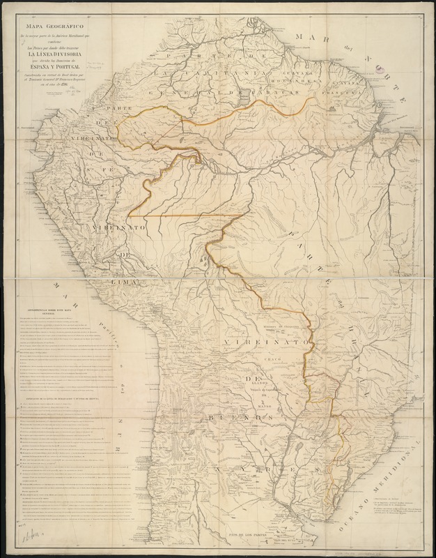
Within the walls of the Oliveira Lima Library there sits a unique collection of watercolors attributed to Spanish mapmaker Francisco Requena y Herrera. The watercolors depict Luso-Hispanic mapping expeditions commissioned under the 1777 Treaty of San Ildefonso to draw a border between Brazil and Spanish South America. Requena was the ranking official of a Spanish mapping team sent to the Amazon, one of many that stretched the ten-thousand-mile border. His watercolors are perhaps the only visual records that portray the labors of the boundary commissions and were likely part of Manoel de Oliveira Lima’s original donation to the library. Oliveira Lima reportedly purchased them in 1914 from Dutch poet and essayist, Martinus Nijhoff, who in turn had acquired them in Spain (Smith, 33). If this account holds true, then Requena most likely brought them with him upon his 1795 return to Spain. Meanwhile, Requena’s maps are scattered across libraries in the United States and Europe, and while some include the same figures as the watercolors, most omit them entirely (Fig. 1).
Beyond being a unique media, Requena’s watercolors are significant for the information they present. Whereas the boundary commissions’ maps provide little indication of the labor involved in their production, these watercolors affirm what is more readily apparent in the diaries of demarcation officers, the expeditions’ account books, and administrative records of the spaces through which they traveled. They demonstrate complex sociocultural interactions that go far beyond Luso-Hispanic diplomacy or scientific knowledge (Siquiera Bueno and Kantor, 253-61). More specifically, they point to the actions of Indigenous and African Americans in response to Iberian efforts to partition the continent. Whereas several dozen diplomats, geographers, cosmographers, astronomers, engineers, and other royal officials produced the expeditions’ documentary corpus, each of the dozens of mapping teams included as many as several hundred guides, contracted laborers, slaves, and armed escorts. Moreover, they traveled through lands claimed and controlled by Indigenous peoples, who alternatively offered resistance or aid (Costa, 117-23).
Take for example the ninth watercolor in the series, titled Cascadas del Río Cuñaré (Fig. 2). From left to right, Requena identifies “Indios Omaguas” rowing a canoe full of provisions, Portuguese officers surveying the landscape with the support of numerous laborers, and Requena himself consulting with an Indigenous man while an African descendant interpreter conversed with two Native women. The image alone provides few details to explain the scene, but in his correspondence, Requena recounted having consulted with Omaguas men and women via a guide (prático do país) named Fernando Rojas. According to Requena, Omaguas communities maintained deep ties to nearby Franciscan missions, trading frequently with them in captives and in goods, and ostensible animosity toward the Portuguese (Quijano Otero, 192-93). Rojas, along with Juan de Silva, were Black men who had reportedly escaped slavery in the Brazilian captaincy of Pará, were fluent in nearby Indigenous languages, and had become principal guides for the Spanish demarcation teams (Roller, 119-20).
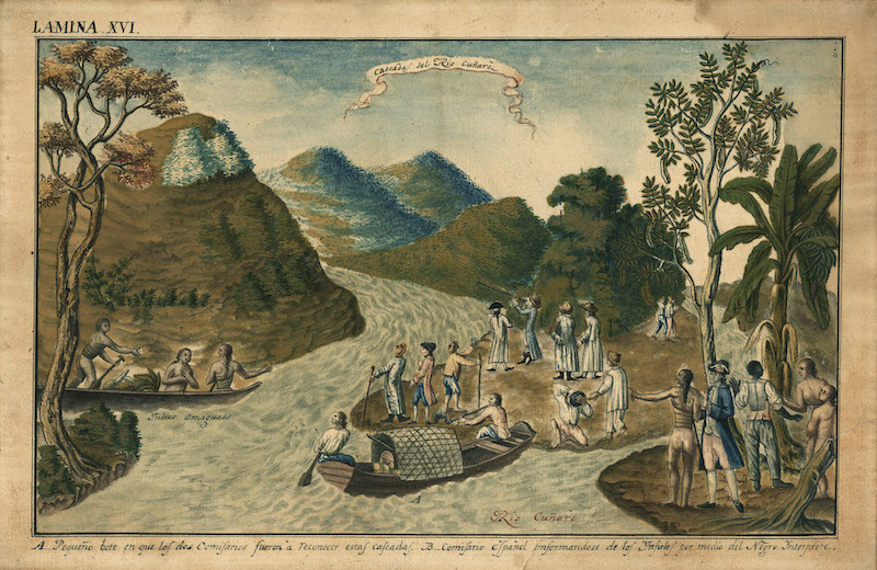
Cascadas del Río Cuñaré captures much of what I found in the research for my book, Where Caciques and Mapmakers Met: Border Making in Eighteenth-Century South America, and for that reason I chose it as the cover image. While Requena’s teams and their Portuguese counterparts surveyed the Amazon, most of the expeditions worked farther south, in the Pantanal (Mato Grosso, Paraguay, and Bolivia) or in the grasslands and forests of southeastern South America (Santa Catarina/Rio Grande do Sul, Argentina, and Uruguay). By situating the southern expeditions within a deeper spatial history of this last region, I found that Native peoples engaged the boundary commissions with their own territorial imaginaries. Rather than part of an ever passing landscape or mere informants, as Iberian mapmakers depicted them to be, Indigenous peoples engaged the boundary commissions to advance their own interests. Guaraní mission-dwellers tend to garner the most attention in this regard, due to a three-year war that they waged against Spanish and Portuguese armies in response to the first attempt at partition. Yet all throughout the purported border, sovereign Native nations asserted their own claims, a fact that forces us to reframe border-drawing not merely as interimperial politics, but rather as interethnic affairs.
Bibliography
Costa, Maria de Fátima. “Viajes en la frontera colonial: Historias de una expedición de límites en la América Meridional (1753-1754).” Anales del Museo de América 16 (2009): 113–126.
Quijano Otero, José María. Límites de la República de los Estados-Unidos de Colombia, vol. 1. Sevilla: Francisco Alvarez y Cía, 1881.
Roller, Heather F. “River Guides, Geographical Informants, and Colonial Field Agents in the Portuguese Amazon.” Colonial Latin American Review 21, no. 1 (2012): 101–126.
Siquiera Bueno, Beatriz Piccolotto, and Iris Kantor. “A outra face das expedições científico-demarcatórias na Amazônia: o coronel Francisco Requena y Herrera e a comitiva castelhana.” In Oliveira, Francisco Roque de, ed. Cartógrafos para toda a Terra: Produção e circulação do saber cartográfico ibero-americano. Lisboa: Biblioteca Nacional de Portugal, 2015, 243–64.
Smith, Robert C. “Requena and the Japurá: Some Eighteenth Century Watercolors of the Amazon and Other Rivers.” The Americas 3, no. 1 (1946): 31–65.